
Social and Environmental Projects
in Madagascar
WHERE WE WORK
ABOUT SOUTHERN MADAGASCAR
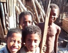
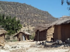
 The south of Madagascar is located south of the equator and is the hottest and driest part of the island. Toliara province spans the south of the island across an area over 70,000square kilometres. It is populated by approximately two million people living in mostly rural environments. This constitutes one of the poorest regions in the country where 88% of the extremely poor are rural producers, women and children suffering from lack of infrastructure, poor roads, and little access to healthcare or schools
67% of children do not attend primary school and approximately three quarters of the rural population are illiterate.
"education, which could give the people the wherewithal to help themselves was seen as too costly, of poor quality and largely irrelevant to the needs of the poor" - World Bank Poverty Assessment 1996.
 The dry spiny forest of the south, a priority conservation zone, is host to unique endemic succulents and species that survive on very little water. However, an estimated 10,000 hectares of the unique spiny forest of the south is lost annually, mostly because of charcoal production for urban areas. The cost of environmental degradation, principally from soil erosion, silting, declining soil fertility and loss of forests has been estimated to be 5-15 % GDP annually.
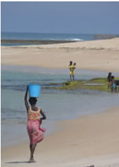
The deep south experiences recurrent drought and 25 % of the population suffer from regular food shortages. The majority of villages are situated 2-5 km from a permanent source of drinking water. During the dry season as many as18 communes (20%) have no access to water within 10km. (EC SAP 2002) and 40% of children under five are malnourished.
 The southern society is polygamous and rural communities still maintain traditional belief systems including ancestral worship, taboos, and magic. Traditionally pastoralists, local people believe that cattle slaughtered at their death will provide for a better afterlife.
 In 1996 a World Bank Poverty Assessment stated ‘Poverty was also characterized by the virtual non-existence of infrastructure and lack of communication and information, especially in the south where over a third of households mentioned the lack of appropriate transportation. For access to information people relied mostly on informal means of communication, including hear and say and the market, where people meet to exchange information’…..‘This isolation leads to powerlessness of small farmers, one clear source of frustration and resentment ‘.
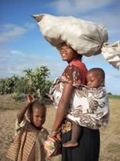 57% of the population (626,204) in the south are Antandroy, the majority are agro-pasturalists engaged in subsistence activities centred on raising livestock and cultivating maize, manioc and sweet potato. However, across most of the region production is insufficient to assure an adequate food supply.
With an average of 400-600mm annual rainfall (SAP) the Androy region’s already low and sinking water table means that accessibility to clean drinking water, and water for agriculture is a serious and growing concern for the region’s population.
The plough was introduced some fifty years ago which, in combination with the strong southern winds, has helped to desertify much of the southern landscape and render the soil infertile or of such poor quality to limit crop yields. Local people in the hardest hit areas will live on raketa mena (prickly pear cactus fruit) for up to, and sometimes more than, three months of the year during an annual hunger gap.